


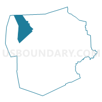
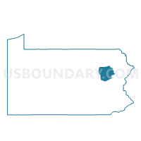
ROSS TWP Voting District, Luzerne County, Pennsylvania
About
Outline

Summary
| Unique Area Identifier | 660865 |
| Name | ROSS TWP Voting District |
| County | Luzerne County |
| State | Pennsylvania |
| Area (square miles) | 43.93 |
| Land Area (square miles) | 43.42 |
| Water Area (square miles) | 0.51 |
| % of Land Area | 98.84 |
| % of Water Area | 1.16 |
| Latitude of the Internal Point | 41.29704230 |
| Longtitude of the Internal Point | -76.18237440 |
Maps

Graphs
Select a template below for downloading or customizing gragh for ROSS TWP Voting District, Luzerne County, Pennsylvania


Neighbors
Neighoring Voting District (by Name) Neighboring Voting District on the Map
- FAIRMOUNT TWP Voting District, Luzerne County, PA
- FORKSTON TWP Voting District, Wyoming County, PA
- HUNLOCK TWP Voting District, Luzerne County, PA
- HUNTINGTON TWP Voting District, Luzerne County, PA
- LAKE TWP Voting District, Luzerne County, PA
- LEHMAN TWP VTD 01, Luzerne County, PA
- UNION TWP Voting District, Luzerne County, PA
Top 10 Neighboring County Subdivision (by Population) Neighboring County Subdivision on the Map
- Lehman township, Luzerne County, PA (3,508)
- Ross township, Luzerne County, PA (2,937)
- Hunlock township, Luzerne County, PA (2,443)
- Huntington township, Luzerne County, PA (2,244)
- Lake township, Luzerne County, PA (2,049)
- Union township, Luzerne County, PA (2,042)
- Fairmount township, Luzerne County, PA (1,276)
- Forkston township, Wyoming County, PA (397)
Top 10 Neighboring Place (by Population) Neighboring Place on the Map
Top 10 Neighboring Unified School District (by Population) Neighboring Unified School District on the Map
- Tunkhannock Area School District, PA (19,039)
- Lake-Lehman School District, PA (16,821)
- Northwest Area School District, PA (9,070)
Top 10 Neighboring State Legislative District Lower Chamber (by Population) Neighboring State Legislative District Lower Chamber on the Map
Top 10 Neighboring State Legislative District Upper Chamber (by Population) Neighboring State Legislative District Upper Chamber on the Map
Top 10 Neighboring 111th Congressional District (by Population) Neighboring 111th Congressional District on the Map
Top 10 Neighboring Census Tract (by Population) Neighboring Census Tract on the Map
- Census Tract 4002, Wyoming County, PA (4,150)
- Census Tract 2159, Luzerne County, PA (3,747)
- Census Tract 2113.02, Luzerne County, PA (3,496)
- Census Tract 2158, Luzerne County, PA (2,937)
- Census Tract 2157.01, Luzerne County, PA (2,443)
- Census Tract 2113.04, Luzerne County, PA (2,049)
- Census Tract 2157.02, Luzerne County, PA (2,042)
Top 10 Neighboring 5-Digit ZIP Code Tabulation Area (by Population) Neighboring 5-Digit ZIP Code Tabulation Area on the Map
- 18655, PA (6,278)
- 18621, PA (6,248)
- 18614, PA (2,426)
- 18656, PA (2,195)
- 18629, PA (1,801)
- 18636, PA (1,438)